
🌐 TH-MX150 — Long-Endurance Industrial Fixed-Wing UAV
One-Pager (English Version)
Professional sales copy — ready for brochures, tenders, government presentations
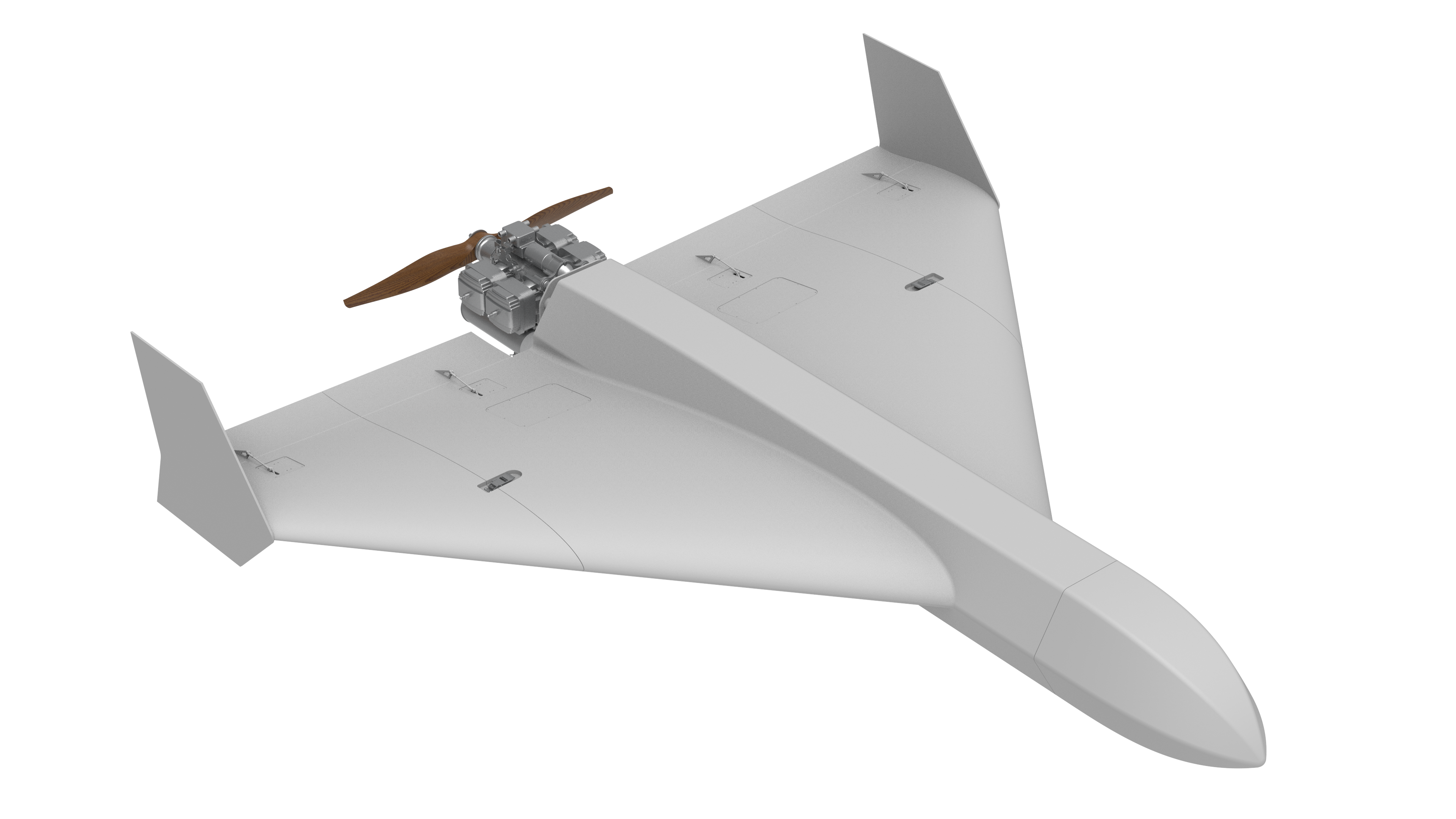
TH-MX150 — Heavy-Duty Fixed-Wing UAV for Large-Area Inspection & Mapping
4–8 hr Endurance · 15–25 kg Payload · 200+ km Range · Designed for Desert & High-Heat Missions
TH-MX150 is a large-scale industrial fixed-wing UAV designed for nation-level mapping, oil & gas pipeline inspection, long-range patrol, power corridor monitoring, and environmental surveillance.
Engineered for desert heat, wind, sand, and large-area missions, it is ideal for Middle East applications.
CORE HIGHLIGHTS
- Ultra-long endurance (4–8 hours) depending on payload configuration
- Large payload bay supporting EO/IR gimbals, Lidar, SAR radar, multispectral sensors, gas-detection modules
- Long-range command link (100–200 km), optional SATCOM
- High wind & heat resistance — optimized for desert operations
- Autonomous takeoff/landing, route planning, terrain following
- Supports BVLOS operations, compliant with industrial & government projects
- Modular design for rapid field assembly and maintenance
KEY APPLICATION SCENARIOS
1. Oil & Gas Pipeline Inspection (ARAMCO / ADNOC / KPC)
- Detect leaks, temperature anomalies, third-party intrusion
- Fly hundreds of kilometers in a single sortie
- Supports methane, VOC sensors, and high-resolution mapping
Customer Benefit: Replace helicopter patrol with 90% cost savings.
2. Long-Distance Transmission Line Inspection
- HV/MV grid corridors (50–200 km per mission)
- Detect hotspots, structural damage, vegetation encroachment
- Compatible with Lidar + EO/IR combo package
Benefit: One aircraft covers what normally requires multiple teams.
3. National-Level Photogrammetry & Mapping
- DEM/DOM/Orthomap generation
- Lidar scanning for cities, desert roads, coastline
- 5–25 kg mapping-grade payloads
Benefit: Survey-grade accuracy for government terrain projects.
4. Border, Coastline & Desert Patrol (Civil Use)
- Coastline monitoring
- Desert vehicle tracking
- Illegal dumping / environmental damage detection
Benefit: Perfect for Middle East vast terrain & harsh climates.
5. Forest Fire Early Detection & Environmental Monitoring
- Long-endurance thermal scanning
- Hotspot recognition
- Air quality / pollution monitoring
Benefit: Multi-hour persistent coverage for national parks & reserves.
SPECIFICATIONS (Typical Configuration)
| Item | Specification |
|---|---|
| Wingspan | 4.5–6.0 m (depending on version) |
| Takeoff Weight | 45–65 kg |
| Payload Capacity | 10–25 kg |
| Endurance | 4–8 hours |
| Cruise Speed | 80–120 km/h |
| Max Range | 200+ km |
| Ceiling | 4500–5500 m |
| Sensors Supported | EO/IR gimbal, mapping camera, Lidar, SAR, multispectral |
| Fuel Type | Electric / hybrid / gasoline options (depending on variant) |
| Takeoff/Landing | Runway / catapult / net landing (variant-specific) |
| Operating Temp | -20°C to +55°C (desert optimized) |
Full datasheet can be delivered if needed.
PACKAGE CONFIGURATION (Example)
TH-MX150 Industrial Mapping Kit
- TH-MX150 UAV ×1
- EO/IR gimbal + mapping camera / Lidar module
- 100–200 km long-range command link
- Mission planning software + ground station
- Portable launch & recovery tools
- Optional:
- SATCOM / LTE hybrid link
- AI pipeline leak detection module
- Desert operation kit (sand filter + heat shielding)
- NESMA local operation & maintenance partnership
Download: TH-MX150_Long-Endurance_Industrial_Fixed-Wing_UAV.pdf
TH-MX150 大型工业固定翼无人机 — 一页纸(中文正式版)
TH-MX150 — 大范围巡检 / 测绘的长航时固定翼无人机
4–8 小时续航 · 10–25 kg 载荷 · 200+ km 巡检半径 · 专为中东高温/风沙环境打造
TH-MX150 是一款面向 能源、电力、石油天然气、国土测绘、海岸/边境巡逻、森林防火 的大型工业级无人机平台。
具备 超长航时、大载荷、大范围覆盖、强环境适应能力,特别适用于沙特、阿联酋、卡塔尔等中东地区的大范围任务需求。
核心亮点
- 4–8 小时超长航时(视载荷而定)
- 10–25 kg 大载荷能力(双光吊舱、激光雷达、SAR、气体检测、测绘相机)
- 100–200 km 图传/指控距离(可选卫星链路)
- 适应沙漠高温、强风、风沙侵蚀环境
- 自动起降、航线规划、地形跟随
- 可执行 BVLOS 超视距任务
- 模块化设计,便于快速维护与更换载荷
典型应用场景
1. 石油天然气管道巡检(ARAMCO / ADNOC)
- 管道泄漏识别
- 第三方入侵监测
- 温度异常检查
- VOC/甲烷检测
- *价值:**替代直升机巡检,成本降低 90%。
2. 输电线路长距离巡检
- 50–200 km 大范围航线
- 绝缘子、金具、导线缺陷识别
- 激光雷达 + EO/IR 组合方案
- *价值:**一架飞机覆盖传统 3–5 个班组的工作量。
3. 国家级航测 / DEM / DOM
- 城市规划
- 沙漠道路、海岸线测绘
- 林区、山区地形扫描
- *价值:**满足政府级测绘精度要求。
4. 边境 / 海岸线 / 荒漠巡逻(民用)
- 海岸线渔业监控
- 车辆活动与非法倾倒识别
- 环境破坏预警
- *价值:**中东广袤地形的最佳巡逻平台。
5. 森林防火监测
- 热点检测
- 烟源识别
- 连续长时间巡护
- *价值:**适合国家公园、自然保护区等场景。
关键参数(典型版)
| 项目 | 参数 |
|---|---|
| 翼展 | 4.5–6.0 米(视版本而定) |
| 起飞重量 | 45–65 kg |
| 载荷能力 | 10–25 kg |
| 续航时间 | 4–8 小时 |
| 巡航速度 | 80–120 km/h |
| 航程 | 200+ km |
| 升限 | 4500–5500 m |
| 支持载荷 | 双光吊舱、测绘相机、激光雷达、SAR、多光谱 |
| 动力 | 纯电 / 混动 / 油动(因版本而异) |
| 起降方式 | 跑道 / 弹射 / 拦网 |
| 工作温度 | -20°C 至 +55°C(沙漠适配) |
典型套装(示例)
TH-MX150 国家级巡检测绘套装
- TH-MX150 主机 ×1
- 双光吊舱 + 测绘相机 / 激光雷达
- 100–200 km 指控链路
- 地面站(含 BVLOS 航线规划工具)
- 可选沙漠适配套件(防尘、散热升级)
- 可选 SATCOM 四网链路
- NESMA 本地运维合作服务(可选)